Добрый день, Коллеги. Важное сообщение, просьба принять участие. Музей Ферсмана ищет помощь для реставрационных работ в помещении. Подробности по ссылке
А.Д. Добровольский. Океанология (вводная лекция к университетскому курсу) М.А. Г лазовская. Общие закономерности географии почв земного шара Т.М. Белякова, А.Г. Вороков, В.Б. Нефедова, Г.С. Самойлов а. Современное состояние медицинской географии в СССР И. Црквенчич, В. Клеменчич. Агрогеографические исследования в Югославии Л.Г. Никифоров. Морфодинамические различия морских берегов Югославии Г.А. Сафьянов. Абразионный процесс и некоторые закономерности развития рельефа абразионного берега Е.Д. Волкова. Основные черты географии сельского хозяйства Закарпатской области УССР A.Е. Федина. Влияние абсолютной высоты на количественные показатели физико-географических комплексов (на примере Северо-Восточного Кавказа) B.А. Николаев. Аридно-денудационные склоны полупустынного Тургая
Remote sensing has been immensely useful in tectonics, structural geology, and geomorphic studies (e.g. Misra et al. 2014; Dasgupta and Mukherjee 2017, 2019; Shaikh et al. 2020; Dasgupta et al. 2022). This edited book consists of 24 chapters authored and co-authored by 53 persons from 21 academic organizations and industries from 7 countries. Misra (2022a; Chapter 1) presents the definition, fundamental processes, and scopes of remote sensing in structural geologic and geomorphologic studies. Misra (2022b; Chapter 2) pens the next introductory chapter, which classifies remote sensing based on data type, source, platform, and imaging media. Gupta and Biswas (2022, Chapter 3) present a morpho-tectonic analysis of a mid-channel bar using remote sensing images from the Jaldhaka river (India). Deota et al. (2022, Chapter 4) present geomorphic indicators of glacier retreat from Jorya-Garang glacier, Baspa Valley (India). They identify different stages of moraines. Jordan (2022, Chapter 5) presents several interesting aerial views of the 2018 Kilauea eruption (U.S.A). Geomorphic features such as lava fissures are documented from images. Awais (2022, Chapter 6) documents different kinds of depositional systems observable in images in Google Earth, viz. different rivers, deltas, lakes, alluvial fans, dunes, and estuaries. Patel et al. (2022, Chapter 7) discuss in detail badland geomorphology from images and several field photos. Their study area was Garbeta (India). Dongare et al. (2022, Chapter 8) discuss the geomorphology of the Indian west coast.
Hillslopes occupy most of the land surface of the Earth. In areas of erosional topography the entire landscape, except the valley floors, consists of hillslopes. Consequently, hillslopes are a major focus of research in geomorphology. The study of hillslopes is essential not only in order to understand better the natural landscape but also for numerous practical reasons, such as controlling soil erosion and sedimentation on agricultural lands and mitigating the hazard posed by landslides. Geomorphologists have studied hillslopes since the latter part of the 19th century, but until the late 1950s their research focused almost exclusively on morphology. During the past 30 years, however, there has been a growing interest in hillslope processes, and today research on processes dominates this branch of geomorphology <...>
Here is the first complete manual on Coastal Geology. A book that gathers the knowledge of more than a century of research on different geological aspects of the coast: dynamics of geological processes, geomorphology, sedimentology and stratigraphy. They are also reflected from the applications of these sciences to the social problems and challenges of the communities occupying coastal areas. This manual collects many of my research experiences on different shores of the world, but almost everything written in this book I learned in other books.
Many dictionaries describe engineering as the business of planning, designing, constructing, and managing machinery, roads, bridges, highways, dams, tunnels, etc. Others have defined it as the art, or even the science, of using power and materials most effectively in ways that are valuable and necessary to man. Engineering has been divided into many subfields, which represent nearly all the activities of man.
Hillslope analysis is a branch of geomorphology whose aims and methods are often not well understood by geographers. Yet the whole of the earth's land surface is formed of slope facets, and an understanding of their form and of the natural processes acting on them is fundamental to geomorphology. One may define a hillslope quite simply as an element of the earth's surface inclined to the horizontal. Thus a slope possesses a gradient, giving it a direction or orientation in space. <...>
The word “geomorphology” is derived from the Greek roots geo (Earth), morphos (shape), and logos (study). Thus, geomorphology is the study of the shape of the Earth’s surface. Schumm (1991) defines geomorphology as the science of phenomena on or near the earth’s surface and the interactions between different types of materials and processes, including solids, liquids and gases. The effects of human activity are often crucial. Some authors consider geomorphology to be one of the most difficult physical sciences (Linton, 1964). Some authors restrict geomorphology to the study of the characteristics of sub-aerial topography but others extend it to the morphology of the ocean floors. Geomorphology also includes the investigation of landforms on other planets; this science is called planetary or extraterrestrial geomorphology (Greeley, 1985; Baker, 1981a; 1993, 2001, 2004a).
Сборник характеризует работу XXII Международного географического конгресса в Канаде.
Освещается работа секций: геоморфологии, гидрологии и океанографии, климатологии, биогеографии и почвоведения, качества среды, экономической географии, географии сельского хозяйства и сельских поселений, культурной географии, исторической географии, рассматриваются вопросы теории географии.
Дается обзор работы комиссий рабочих групп Международного географического союза. Приводятся материалы научных наблюдений во время полевых экскурсий по горным и степным районам западной части Канады
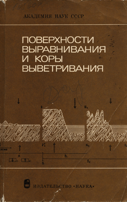
В сборнике даны материалы Международного симпозиума, состоявшегося в июне 1974 г. в г. Ленинграде. Приводятся материалы по недавно опубликованной карте поверхностей выравнивания и кор выветривания в СССР. Работа рассчитана на широкий круг геоморфологов.