Добрый день, Коллеги. Важное сообщение, просьба принять участие. Музей Ферсмана ищет помощь для реставрационных работ в помещении. Подробности по ссылке
Третий заключительный выпуск Тезиоов Всесоюзного совещания "Сдвиговые тектонические нарушения и их роль в образовании месторождений полезных ископаемых" в полной мере отражает огромное значение сдвигов в формировании всех типов месторождений полезных ископаемых - рудных, нерудных и горючих. Далеко не случаен тот факт, что на соответотвующуй секцию нашего совещания поступило наибольшее количество докладов, что подтверждает как масштабы интереса, так и практическую значимость данной проблемы для отечественной геологической службы.
Most of the North American continent is underlain by long-cratonized crust. However, the geologists’, geochemists’ and geophysicists’ attention is mainly focused on the surrounding mobile megabelts. Only few publications consider the North American craton as a whole and attempt to review its entire history from the Late Archean to the present. Even in the last, as yet unfinished synopsis, created under the label Decade of North American Geology (DNAG), the geology of the craton is divided between volumes separately considering the Canadian Shield and cratonic platforms, platformal cover and basement, in the U.S. and Canada. <...>
The word “geotectonics” is derived from two ancient Greek words: ge, “the earth,” and _ tektonike, “building.” This branch of science is sometimes called simply “tectonics,” but some writers tend to use “tectonics” to refer only to the morphologic aspects of geotectonics—the description of rock structure—and to use “geotectonics” for more general problems. <...>
Physicists attempt to reduce natural phenomena to their essential dimensions by means of simplification and approximation and to account for them by defining natural laws. Paradoxically, whilst there is a critical need in geology to reduce the overwhelming field information to its essentials, it often re- mains in an over-descriptive state. This prudent attitude of geologists is dictated by the nature of the subjects being considered, as it is often difficult to derive the significant parameters from the raw data.
In geologic terms, a plate is a large, rigid slab of solid rock. The word tectonics comes from the Greek root "to build." Putting these two words together, we get the term plate tectonics, which refers to how the Earth's surface is built of plates. The theory of plate tectonics states that the Earth's outermost layer is fragmented into a dozen or more large and small plates that are moving relative to one another as they ride atop hotter, more mobile material. The diagrams below show the break-up of the supercontinent Pangaea (meaning "all lands" in Greek), which figured prominently in the theory of continental drift -- the forerunner to the theory of plate tectonics. <...>
Летникова Е.Ф., Иванов А.И., Ветров Е.В., Бродникова Е.А. Доордовикские осадочные бассейны Тувино-Монгольского микроконтинента и «тувинских» террейнов - родственникиили соседи? Лосив В.М. Новая модель формирования Сихотэ-Алинской складчатой системы Лубнина Н.В., Бычков А.Ю., Тарасов Н.А., Зверев А.Р. Свекофенское перемагничивание докембрийских комплексов Карельского кратона: продолжительность и пространственное распространение Лукашов А.А., Дубинин Е.П., Грохольский А.Л., Щербакова Е.Л., Доманская П.А. Неотектоническое строение и модель развития погруженного плато и острова Сокотра (физическое моделирование) Лучицкая М.В., Соколов С.Д., Пиис В., Миллер Э., Беляцкий Б.В. Гранитоидный меловой магматизм Восточной Чукотки: состав, возраст и геодинамическая обстановка формирования Мазарович А. О., Ольшанецкий Д.М. Оползни и новейшие движения на побережье Западной Камчатки (Точилинский разрез)
Williams, G. D. Tectonics and seismic sequence stratigraphy: an introduction Cartwright, J. A., Haddock, R. C. & Pinheiro, L. M. The lateral extent of sequence boundaries Prosser, S. Rift-related linked depositional systems and their seismic expression Waltham, D., Hardy, S. & Abousetta, A. Sediment geometries and domino faulting Roberts, A. M., Yielding, G. & Badley, M. E. Tectonics and bathymetric controls on stratigraphic sequences within evolving half-graben Joy, A. M. Comments on the pattern of post-rift subsidence in the Central and Northern North Sea Basin Higgs, W. G. & McClay, K. R. Analogue sandbox modelling of Miocene extensional faulting in the Outer Moray Firth Light, M. P. R., Maslanyj, M. P., Greenwood, R. J. & Banks, N. L. Seismic sequence stratigraphy and tectonics offshore Namibia Deramond, J., Souquet, P., Fondecave-Wallez, M-J. & Specht, M. Relationships between thrust tectonics and sequence stratigraphy surfaces in foredeeps: model and examples from the Pyrenees (Cretaceous-Eocene, France, Spain)
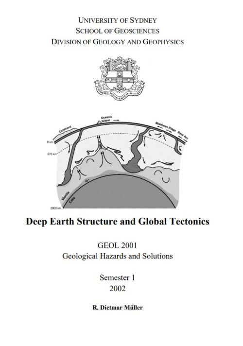
The study of seismic wave propagation, especially of the P (longitudinal) waves, has enabled us to distinguish two components in the shallower part of the earth:
- The crust (thickness varying from 10 to 70 km, average 30 Ian);
- The underlying mantle, separated from the crust by a surface of discontinuity at which the seismic-wave velocities change suddenly (the Mohorovicic discontinuity, generally shortened to Moho).
Начасова И.Е., Марков Г.П. Вариации главного геомагнитного поля на территории Евразии в последние тысячелетия Никишин А.М., Казмин Ю.Б., Петров Е.И., Глумов И.Ф., Лобковский Л.И., Малышев Н.А., Посёлов В.А., Буров Е.Б., ГайнаК. Строение и история формирования Арктического океана Никонов А.А., Усольцева О.А., Гамбурцева Н.Г., Гамбурцев А.Г., Кузнецов О.П. Проблемы современной геодинамики Балтийского щита: исследование на основе новых разработок Паверман В.И., Шацилло А.В., Ко Р., Жао Щ., Гладкочуб Д.П., Бухвальд Р., Павлов В.Э. Палеогеография Сибирской платформы в среднепалеозойское время (~450-400 млн лет): новые палеомагнитные и геохронологические свидетельства из Нюйской впадины
Павленкова Н.И. Особенности строения литосферы континентов и океанов и природа их формирования Паланджян С.А., Пугачёва Е.Е. К палеотектонической позиции метаморфизма улирамафитов хребта Пекульней (АнадырскоКорякский регион)
1. Assembly of central Asia during the middle and late Paleozoic Christoph Heubeck 2. Paleozoic tectonic amalgamation of the Chinese Tian Shan: Evidence from a transect along the Dushanzi-Kuqa Highway Da Zhou, Stephan A. Graham, Edmund Z. Chang, Baoyu Wang, and Bradley Hacker 3. Sinian through Permian tectonostratigraphic evolution of the northwestern Tarim basin, China Alan R. Carroll, Stephan A. Graham, Edmund Z. Chang, and Cleavy McKnight 4. Uplift, exhumation, and deformation in the Chinese Tian Shan Trevor A. Dumitru, Da Zhou, Edmund Z. Chang, Stephan A. Graham, Marc S. Hendrix, Edward R. Sobel, and Alan R. Carroll 5. Tectonic correlation of Beishan and Inner Mongolia orogens and its implications for the palinspastic reconstruction of north China Yongjun Yue, Juhn G. Liou, and Stephan A. Graham 6. Paleozoic sedimentary basins and volcanic arc systems of southern Mongolia: New geochemical and petrographic constraints Melissa A. Lamb and Gombosuren Badarch