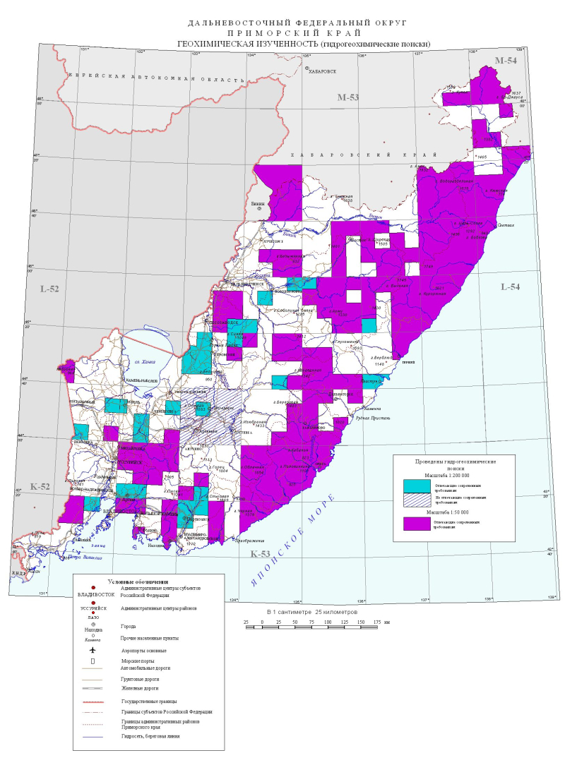
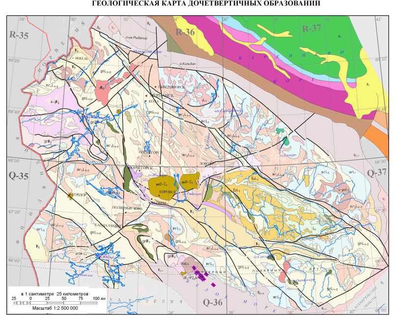
Добрый день, Коллеги. Важное сообщение, просьба принять участие. Музей Ферсмана ищет помощь для реставрационных работ в помещении. Подробности по ссылке
В 1955 г. по инициативе Геологического института Академии наук СССР, Лаборатории геологии угля Академии наук СССР и Всесоюзного научно-исследовательского геологического института Министерства геологии и охраны недр СССР было начато составление Атласов углей угольных бассейнов и районов СССР.
На 1100 фото, фотопанорамах, разрезах и картах показано современное геологическое строение Крыма. С позиций актуалистической геодинамики, приведены новые интерпретации уникальных геологических объектов. На фоторисунках обосновано выделение региональных меланжей, сложных шарьяжных складок, надвигов и оползневых комплексов. Приведены короткие пояснения строения, список литературы и словарь терминов. Атлас может использоваться как основа для создания общепринятой модели строения Крыма, а также как путеводитель при геологических, географических и природоведческих экскурсиях
Министерством геологии СССР и Академией наук СССР при участии других ведомств (Министерства высшего образования, Министерства нефтяной и газовой промышленности и др.) в 1960_1966 гг. для территории СССР составлен Атлас, состоящий из литолого-палеогеографических и палеотектонических карт масштаба 1: 7 500 000 и, как исключение, 1:15 ООО 000, а также ряда карт разных масштабов, характеризующих условия накопления некоторых полезных ископаемых осадочного происхождения, обстановок осадконакопления и др. Атлас состоит из 4-х томов.
Cet Atlas de Pétrologie s'adresse en premier lieu à tous les étudiants engagés en cursus de Licence dans les domaines des sciences de la vie et de la Terre. Construit sous forme de fiches en double page et abondamment illustré, cet ouvrage offre une vision synthétique sur un ensemble de minéraux et de roches magmatiques, sédimentaires et métamorphiques, les plus fréquemment rencontrés et dont la reconnaissance fait l'objet de séances de travaux pratiques. li est aussi l'occasion de découvrir les roches extraterrestres avec l'étude des météorites et d'aborder certains domaines de la géologie appliquée avec l'étude de ressources naturelles dans leurs gisements et leurs utilisations. <...>
A forerunner of the ATLAS was first published in 1970(1). This early survey comprised 27 zeolite structures known at the time. Then the "Atlas of Zeolite Structure Types" by W.M. Meier and D.H. Olson, with 38 entries, was published by the Structure Commission of the IZA in 1978. This was followed by the much expanded 2nd edition of the ATLAS in 1988 comprising 64 entries, the updated 3rd edition in 1992 with 85 entries, and the fully revised 4th edition in 1996 with 98 entries. This 5th edition is again an updated version of the previous compilation, and the number of entries has risen significantly to 133.
Analyses of geological structures from field exposure of rocks have been one of the important and intriguing disciplines in (applied) Earth Sciences. Since the 1990s, especially after the boom of three‐dimensional seismic technologies, reflection seismic data in two and three dimensions have become the modern ‘field’ for geologists. A large number of exploration geoscientists analyze reflection seismic data to interpret sedimentary sequences and deformation structures to provide prospective leads for exploration in their respective industries. Today, seismic data are used extensively in industries such as hydrocarbon and mineral exploration, carbon dioxide sequestration, sea floor hazard surveys for cables and pipelines and so on. This book primarily deals with reflection seismic data in the hydrocarbon industry.