Добрый день, Коллеги. Важное сообщение, просьба принять участие. Музей Ферсмана ищет помощь для реставрационных работ в помещении. Подробности по ссылке

Поиск по книгам
Редактор(ы):Turekian K.K., Holland H.D.
Издание:2014 г., 8014 стр.
Язык(и)Английский
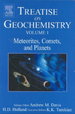
Treatise on Geochemistry. Volume 1. Meteorites and cosmochemical processes / Трактат по геохимии. Том 1. Метеориты и космохимические процессы

The first volume of the Treatise on Geochemistry, 2nd Edition covers the chemistry of meteorites and some of their important components, as well as interplanetary dust particles, cosmochemical processes, and chronology. We have learned a great deal about the present-day solar system from flying by, orbiting, and landing on planets, asteroids, and comets with spacecraft, but the earliest history of the solar system has been obscured by subsequent geological processing on the terrestrial planets. Meteorites and their constituents provide unique witnesses to planet formation, the formational stages of the solar nebula, and even stars that lived their entire lives before the solar system was born <...>

Редактор(ы):Davis A.M., Turckian K.K., Holland H.D.
Издание:Elsevier, 2003 г., 203 стр., ISBN: 0-08-043751-6
Язык(и)Английский
Treatise on Geochemistry. Volume 1. Meteorites, comets and planets / Фундаментальный трактат по геохимии. Часть 1. Метеориты, кометы, планеты

Treatise on Geochemistry это первая в своем роде работа, с глобальным интегрированным подходом к современному состоянию Геохимии. В Трактате освещены все основные разделы геохимии, от химии солнечной системы, до экологической геохимии. В Treatise on Geochemistry использованы труды выдающихся мировых ученых и включены ссылки на самые современные публикации. Труд включает в себя 9 томов, каждый из которых состоит из 15-25 разделов, составленных ведущими авторитетами в данной области знаний. Treatise on Geochemistry в электронном формате включает в себя систему разветвленных ссылок, облегчающих навигацию по документу.

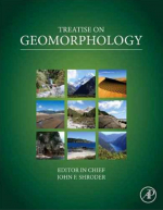
Редактор(ы):Shroder L.F.
Издание:Elsevier, 2013 г., 5777 стр.
Язык(и)Английский
Treatise on geomorphology / Трактат по геоморфологии

Geomorphology, the study of landforms and their formative processes, is a multidisciplinary field most strongly associated with the geographical and geological sciences. It encompasses numerous subfields of specialization that are not necessarily mutually exclusive. Like all disciplines, what geomorphology is like today derives in part from the practitioners, ideas, controversies, and events involved in its development. This paper presents a brief perspective and overview of the history of geomorphology as an introduction to the subsequent chapters in the volume, each of which focuses on a specific period of the discipline’s history or on concepts that have figured prominently in its past development or current status. A brief summary of the following 18 papers in this volume provides insight into the range of ideas and methods that are engaged in the theory and practice of geomorphology. The volume as a whole provides historical and thematic context for the subsequent volumes in the Treatise on Geomorphology. <...>

Том 4
Редактор(ы):Beroza G.C., Kanamori H.
Издание:Elsevier, 2007 г., 691 стр., ISBN: 978-0444519283
Язык(и)Английский
Treatise on geophisics.  Earthquake seismology. Volume 4/ Трактат о геофизике. Сейсмология. Том 4

In general usage, the term ‘earthquake’ describes a sudden shaking of the ground. Earth scientists, however, typically use the word ‘earthquake’ somewhat differently – to describe the ‘source’ of seismic waves, which is nearly always sudden shear slip on a fault within the Earth (see Figure 1). In this article, we follow the scientific usage of the term, and focus our review on how earthquakes are studied using the motion of the ground remote from the earthquake source itself, that is, by interpreting the same shaking that most people consider to be ‘the earthquake’. The field defined by the use of seismic waves to understand earthquakes is known as earthquake seismology. The nature of the earthquakes makes them intrinsically difficult to study. Different aspects of the earthquake process span a tremendous range in length scales – all the way from the size of individual mineral grains to the size of the largest plates. They span a tremendous range in timescales as well. The smallest micro-earthquakes rupture faults for only a small fractionof a second andthe durationof even the verylargest earthquakes can be measured in hundreds of seconds. Compare this with the length of strain accumulation in the earthquake cycle, which can be measured in decades, centuries, and even millenniums in regions of slow strain rate. The evolution of fault systems spans longer times still, since that can require the action of thousands of earthquakes. At different physical dimensions or temporal scales, different physical mechanisms may become important, or perhaps negligible. Earthquakes occur in geologically, and hence physically, complicated environments. The behavior of earthquakes has been held up as a type example of a complex natural system. The sudden transformation of faults from being locked, or perhaps slipping quasistatically, to slipping unstably at large slip speeds, as is nearly universally observed for earthquakes, also makes them a challenging physical system to understand. Despite these challenges, seismologists have made tremendous progress in understanding many aspects of earthquakes – elucidating their mechanisms based on the radiated seismic wavefield, determining where they occur and the deep structure of faults with great precision, documenting the frequency and the regularity (or irregularity) with which they occur (and recur) over the long-term, gaining insight into the ways in which they interact with one another, and so on. Yet, the obvious goal of short-term prediction of earthquakes, that is specifying the time, location, and size of future significant earthquakes on a timescale shorter than decades, remains elusive. Earthquakes are different in this sense from nearly all other deadly natural hazards such as hurricanes, floods, and tornadoes, and even volcanic eruptions, which to varying degrees are predictable over a timescale of hours to days. The worst earthquakes rank at the very top of known disasters. The deadliest known earthquake killed over half a million people in a matter of minutes.

Том 8
Редактор(ы):Olson P.
Издание:Elsevier, 2007 г., 352 стр., ISBN: 978-0444519283
Язык(и)Английский
Treatise on geophisics. Core Dynamics. Volume 8/ Трактат о геофизике. Динамика ядра. Том 8.

For as long as man has speculated about the interior of the Earth, it has been presumed that there exists a central core. Centuries before the rise of modern science, philosophers, and theologians had concluded that the Earth has a hot region at its center, with properties distinct from all other parts of the planet. For nearly as long a time it has been known that the Earth is also magnetic, but the cause of the Earth’s agnetism remained just as mysterious as the nature of the deep interior. Scientific inquiry about the core grew from early investigations of the properties of the geomagnetic field, which began during the era of global exploration. Although the ancient Chinese deserve the credit for discovering Earth’s magnetism, Gilbert (1600) was the first to demonstrate that the compass needle is controlled by a force originating within the Earth (Figure 1). He showed that the pattern of magnetic field lines on a uniformly magnetized sphere approximate the known directions of the compass needle over the Earth’s surface. Three hundred and fifty years later, Sidney Chapman characterized Gilbert’s demonstration as ‘‘the only successful experiment in the history of geomagnetism!’’ Later it was observed that Earth’s magnetic field changes slowly with time. In his famous explanation for this secular variation, Halley (1683, 1692) proposed that the geomagnetic field has its origin near the Earth’s center, in a region separated from the solid crust by a cavernous, fluidfilled shell. Halley (Figure 2) envisioned that both the crust and the central region or core rotate in the prograde sense, but the core spins slightly slower, causing the magnetic field to drift systematically westward as seen at the surface. Thus, two important and long-lasting concepts were born: the basic three-layer model of Earth’s interior (solid crust and mantle, liquid outer and solid inner core), and the association between the westward geomagnetic drift and westward motion of the fluid outer core with respect to other parts of the Earth system. Halley’s model implicitly assumed that the magnetic field originated in a solid inner core (Evans, 1988), akin to Gilbert’s uniformly magnetized sphere. Subsequently, it was shown that Halley’s model is at variance with the ferromagnetic properties of Earth materials, which lose their permanent magnetization at the Curie temperature at depths of a few tens of kilometers beneath the surface (see Chapter 5.06). However, by then the physical connection between magnetic fields and electric currents had been established, providing an alternative explanation for the geomagnetic field that relied on free electric currents rather than permanent magnetization.

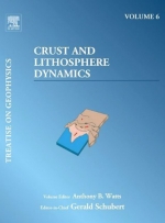
Том 6
Редактор(ы):Watts A.B.
Издание:Elsevier, 2007 г., 604 стр., ISBN: 978-0444519283
Язык(и)Английский
Treatise on geophisics. Crust and Lithosphere Dynamics. Volume 6/ Трактат о геофизике. Земная кора и динамика литосферы. Том 6.

It has been known since the pioneering work of Joseph Barrell during the early part of the last century that the outermost layers of the Earth comprise a strong upper layer, the lithosphere, which overlies a weak lower layer, the asthenosphere. Barrell (1914a) argued that because river deltas such as the Niger and Nile lack a flanking topographic depression, they must be supported by the strength of the lithosphere. He used (Barrell, 1914b) Pratt isostatic gravity anomalies over North America as a proxy for the magnitude of the stress differences that could be supported by the lithosphere and showed, using the equations of Darwin (1882), that stresses increase and then decrease with depth, passing by transition into the weak underlying asthenosphere. Today, we distinguish the lithosphere from the asthenosphere not only on the basis of its strength, but its physical properties such as temperature, density, and seismic velocity structure. The lithosphere, for example, is generally associated with cooler temperatures, higher average densities, and higher average S-wave velocities than the asthenosphere. Plate tectonics is based on the assumption that the lithosphere is rigid on long timescales and is moving across the surface of the Earth with the plates. The positive density contrast between the lithosphere and the asthenosphere suggests, however, that the rigid layer may be gravitationally unstable. Indeed, oceanic lithosphere – after it is created at a mid-oceanic ridge – cools, subsides, and sinks into the underlying asthenosphere, for example, at a deep-sea trench–outer-rise system.Continental lithosphere may also be unstable. In rifts (e.g., East Africa) the lithosphere is regionally heated, thinned, and uplifted and only subsides locally below sea level. In collisional systems (e.g., Himalaya, Betics), however, continental lithosphere is thickened (Molnar et al., 1998) or is infiltrated by fluids released during metamorphic reactions (Le Pichon et al., 1997). Both processes may cause dense rocks of the lower crust to enter the eclogite stability field. As a result, the lower crust becomes denser than the underlying mantle, detaches, and, as at trenches, may sink into the underlying asthenosphere. Isostatic considerations, however, suggest that the crust – which comprises the uppermost part of the lithosphere – is buoyant and is in a state of flotation on the underlying mantle. Furthermore, flexure studies suggest that when it is subject to long-term geological loads such as volcanoes and sediment, the lithosphere, rather than behaving as a number of independent floating blocks, as local models of isostasy such as Airy and Pratt predict, responds by bending – in a similar manner as would an elastic plate that overlies an inviscid fluid substrate.

Том 9
Редактор(ы):Stevenson D.J.
Издание:Elsevier, 2007 г., 313 стр., ISBN: 978-0444519283
Язык(и)Английский
Treatise on geophisics. Evolution of the Earth. Volume 9 / Трактат о геофизике. Эволюция земли. Том 9

Evolutionary science is for the most part based on observation and indirect inference. It is not experimental science, even though experiments can certainly play a role in our understanding of processes. We can never hope to have the resources to build our own planet and observe how it evolves; we cannot even hope (at least in the foreseeable future) to observe an ensemble of Earth-like planets elsewhere in the universe and at diverse stages of their evolution (though there is certainly much discussion about detection of such planets; e.g., Seager (2003)). There are two central ideas that govern our thinking about Earth and its history. One is ‘provenance’: the nature and origin of the material that went into making Earth. This is our cosmic heritage, one that we presumably share with neighboring terrestrial planets, and (to some uncertain extent) we share with the meteorites and the abundances of elements in the Sun. The other is ‘process’: Earth is an engine and its current structure is a consequence of those ongoing processes, expressed in the form it takes now. The most obvious and important of these processes is plate tectonics and the inextricably entwined process of mantle convection. However, this central evolutionary process cannot be separated from the nature of the atmosphere and ocean, the geochemical evolution of various parts of Earth expressed in the rock record, and life. Figure 1 shows conceptually the ideas of Earth evolution, expressed as a curve in some multidimensional space that is here simplified by focusing on two variables (‘this’ and ‘that’), the identities of which are not important. They could be physical variables such as temperature, or chemical variables (composition of a particular reservoir) or isotopic tracers. The figure intends to convey the idea that we have an initial condition, an evolutionary path, and a present state. The initial condition is dictated not only by provenance but also by the physics of the formation process. By analogy, we would say that the apples from an apple tree owemuch of their nature not only to the genetics of apples (the process of their formation) but also, to some extent, the soil and climate in which the tree grew.We are informed of this initial condition by astronomy, which tells us about how planets form in other solar systems, by geochemistry (a memory within Earth of thematerials and conditions of Earth formation), and by physical modeling: simulations and analysis of what may have occurred. Notably, we do not get information on the initial condition from geology since there are no rocks or landforms that date back to the earliest history of Earth. Geology, aided by geochemistry and geobiology, plays a central role informing us about Earth history. Though some geophysicists study evolution, nearly all geophysical techniques are directed toward understanding a snapshot of present Earth, or a very short period prior to present Earth, and it is only through modeling (e.g., of geological data) that the physical aspects of evolution are illuminated.

Том 3
Редактор(ы):Herring T.A.
Издание:Elsevier, 2007 г., 441 стр., ISBN: 978-0444519283
Язык(и)Английский
Treatise on geophisics. Geodesy. Volume 3/ Трактат о геофизике. Геодезия. Том 3.

Modern geodesy as discussed in this volume started with the development of distance measurement using propagating electromagnetic signals and the launch of Earth-orbiting satellites. With these developments, space-based geodesy allowed global measurements of positions, changes in the rotation of the Earth, and the Earth’s gravity field. These three areas (positioning, Earth rotation, and gravity field) are considered the three pillars of geodesy. The accuracy of current measurement systems allows time variations to be observed in all three areas. Also the complexity of problems is such that each of the pillars interacts with each other and also with many other branches of Earth Science. This interaction is most apparent in the role that water plays in modern geodetic measurements. Every chapter in this volume mentions the role of water. It is critical because it can move rapidly and over large distances; it can exist in all three phases, gas, fluid, and solid; and modern geodetic methods are accurate enough that their measurements are sensitive to its effects. In its vapor form, its refractive properties delay microwave signals propagating through the Earth’s atmosphere. For geodetic positioning, this is a noise source but it is a signal for metrological applications. In the liquid form, it forms oceans that affect both the tidal signal and the rotation of the Earth. Also in liquid form, its mass changes the gravity field as it is moved through the hydrologic cycle. In solid form, it has a gravitational and deformation signal that changes if melting of the ice unloads the surface of the Earth. The interactions between the pillars include the elastic loading effects of changing mass loads that can be seen in the gravity field and in the positions of ground stations. The movement of water to and from the oceans can be seen with altimeter satellites whose orbital information is derived from measurements from ground stations whose positions are affected by the changing mass load. In modern, time-dependent geodetic data analysis these interactions need to be accounted for. The common interface between the geodetic methods is the coordinate systems and reference frames used to analyze data. Coordinate systems and the associated reference frames form a core theme of the chapters in this volume. Two other unifying themes are the measurement systems of geodesy that are used again throughout the volume, and interplay of errors in measurements, signals, and noise. In this chapter weexamine these three themes.

Том 5
Редактор(ы):Kono M.
Издание:Elsevier, 2007 г., 582 стр., ISBN: 978-0444519283
Язык(и)Английский
Treatise on geophisics. Geomagnetism. Volume 5/ Трактат о геофизике. Геомагнетизм. Том 5.

The Earth has its own magnetic field (the geomagnetic field), which is confined by the action of the solar wind into a volume called the magnetosphere (see Chapter 5.03). This field is not steady, but varies with time due partly to the interaction with the solar wind, but more importantly by its own physical processes. Direct observation of such changes has been carried out only in the last few centuries, but with indirect measurements we can understand the field behavior millions of years back in time. In this extended time frame, there is evidence that the polarity of the magnetic field reversed frequently, and that the magnetic dipole axis in very ancient times was significantly displaced from the present rotational axis (the North and South geographic Poles). It is of considerable interest how such knowledge was acquired over several centuries. We will take a brief tour of the historical events that provided important steps in formulating our understanding of the geomagnetic field. In doing so, we have to rely solely on the written records, which is the reason why only the European and Chinese histories are referred. There are many works on this topic; among them, the important ones are Mitchell (1932–46), Harradon (1943–45), Needham (1962), and Yamamoto (2003). The English translations of Chinese literature below were taken from Needham (1962). Chinese sentences given together with English were taken from the Japanese translation of this book (Hashimoto et al., 1977). When we talk about the earliest recognition of the magnetism of the Earth, we should be careful to discriminate two separate issues; that is, the attractive force exerted by a magnet on iron, and the north- (or south-) seeking property of the magnet. The former can be taken as the forerunner to the science of magnetism, while the latter is the basis for appreciation of the magnetic field associated with the Earth. Our main interest is in the geomagnetic field, but it is necessary to look into magnets first.

Том 7
Редактор(ы):Bercovici D.
Издание:Elsevier, 2007 г., 500 стр., ISBN: 978-0444519283
Язык(и)Английский
Treatise on geophisics. Mantle Dynamics. Volume 7/ Трактат о геофизике. Динамика мантии. Том 7.

Much of what we refer to as geology, or more accurately geological activity on Earth, is due to the simple act of our planet cooling to space. What allows this activity to persist over the lifetime of the solar system is that the major and most massive portion of the planet, namely the mantle, is so large, moves so slowly, and cools so gradually that it sets the pace of cooling for the whole Earth.

1638.15